


National Geographic Maps - AdventureSouthern Sweden and Norway Map (National Geographic Adventure Map, 3301)
T**R
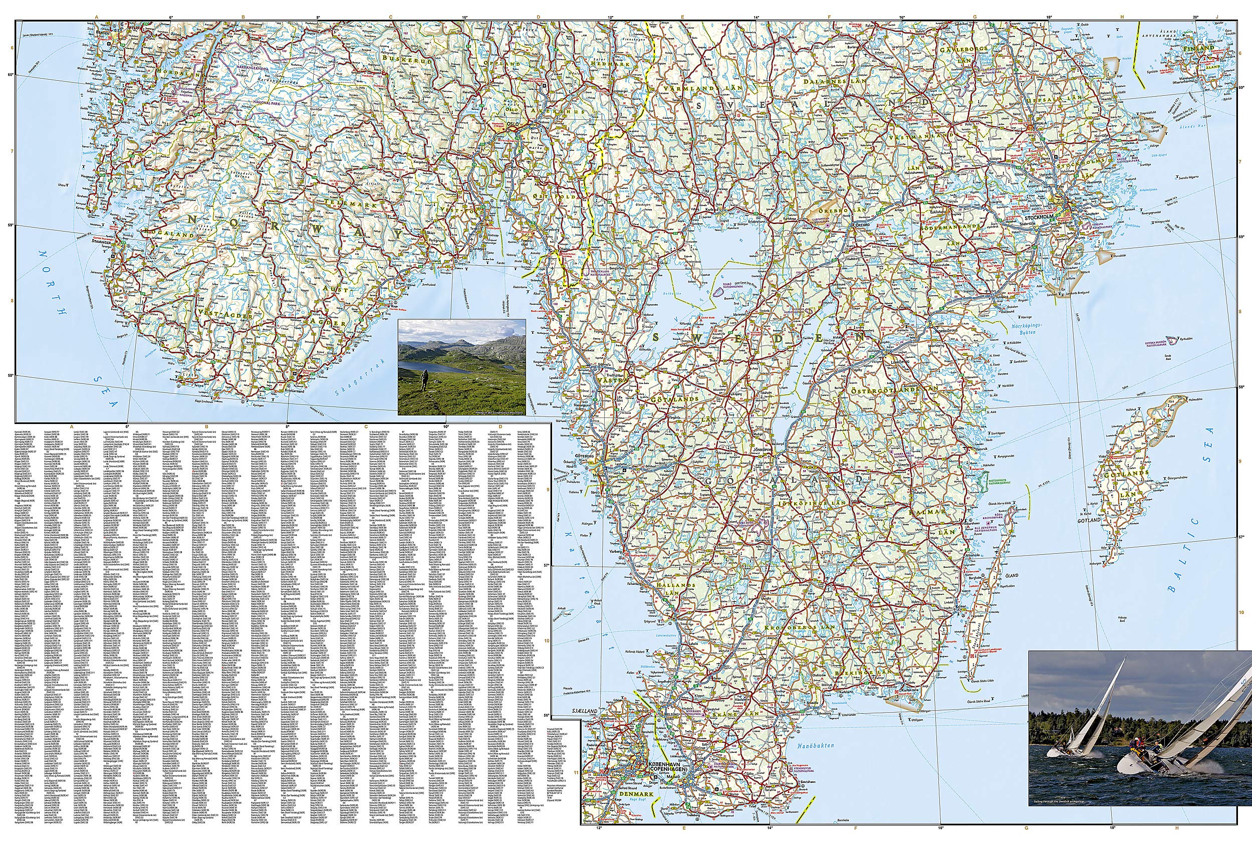
A detailed, clear, easy to read map.
We used (and needed) a GPS to find the local addresses of the AirBnB places we stayed, but this paper map was necessary to plot overland routes and identify points of interest, such as the stave churches, that we wanted to see. Great for planning, great during driving. And no matter what they say (truly) about the spectacular fjords, they pale when compared to the scenery you see when driving.
P**R
Map of southern Sweden.
Helpful map of southern Sweden and Norway with clear road signs.
M**N
... when they were driving through Scandinavia and this was perfect. It was of good quality and had all ...
I wanted to get a durable and accurate map for my sons when they were driving through Scandinavia and this was perfect. It was of good quality and had all of the needed information. I highly recommend this and other Nat Geo maps.
S**A
Great for trip-planning, need more help for backcountry roads
This map is excellent for overall planning for your trip, answering questions like “is that a 50 mile drive or a 500 mile drive?”, is tear- and water-resistant, and up to the high visual-quality standards of NG and Michelin. However at 15 miles per inch, you are not going to get much help for driving on little country roads... and this year we still haven’t figured out reasonable roaming charges for running google maps in real time on your cellphone, although the EU is moving in this direction. Anyway google maps has always been better at finding urban pizza places as opposed to rural landscape features, and you can’t count on a nearby cellphone tower when you are really out deep in the countryside...I am writing a somewhat more general review here because I see a lot of readers are looking for help planning to drive around, maybe some advice.For travel in Norway, a much more detailed complement to this NG low-resolution map is the annual, big, red, spiral-bound, expensive “Stort bilatlas Norge” (that’s Big CarAtlas Norway), published by Cappelen Damm— maybe buy it in Norway but I found it was a lot of help to get it in advance. Don’t worry, it has titles in German and English, but you really need Norwegian too if you want to read local signs. As of the time I’m writing this review, Amazon USA doesn’t carry this atlas, but maybe this review will help change their mind, I hope. At roughly three times the resolution of the NG map of this review, it has nine times as much area coverage, also good city-maps and gazetteer, is quite legible. Don’t settle for last year’s copy because Norway is constantly constructing new tunnels and bridges, e.g., to wonderful, obscure little islands. There are still a lot of ferrries that play the role of bridges on major roads, so patience is encouraged. Even though it’s expensive to rent a car in Norway, you might consider doing this at several ports serviced by (the) HurtigRutEn, just like the people who get off and on the Alaska Ferries. You might also find bargains on the far-north local airlines, or consider a (gorgeous) rail connection to Narvik from Sweden’s InlandsBanEn. At latitudes like Prudhoe Bay (snowmobile country in the USA/Canada), Norway has through-roads, restaurants, cellphones, car rentals, farmers who are gathering in the first hay at the end of May just like in Vermont (oh, well, they also have herds of reindeer with numbers painted on them, not a typical Vermont feature). Oh and a terrific university bookstore in Tromso. Beware midges, like in Scotland. Well, I guess this NG map doesn’t extend that far north, but don’t let that stop you from Dreaming. Be warned, also, that north of the Arctic Circle, roads are generally small-sized, windy, slow going, i.e. more tiring driving. But anyway the word “Adventure” in the title of this map does conjure up some adventuring in the beautiful Scandinavian countryside, it will help you start to get there, and I hope you have a wonderful time traveling around.
G**E
Very useful tool as we drove around southern Sweden & Norway
Very useful tool as we drove around southern Sweden & Norway. Even though we had a GPS we used the map a lot to find spots of interest including an interesting heritage sight with age-old petroglyphs.
G**N
Southern Scandinavia
This is ideal as there are 3 countries in this map and is made of waterproof material. Has all the info we require for our journey to the northern hemisphere
L**
Scale too large
Not enough details on these maps to be useful and the scale is larger than useful
B**N
Magnify
You need a good strong magnifying glass to read
T**D
Laminate finish makes it tear and water resistant.
The laminate finish allows for erasure of dry erase marker enabling immediate and simple route planning changes.
A**R
Five Stars
Très belle carte au fini durable.
A**R
Five Stars
helped with our trip
Trustpilot
1 day ago
2 weeks ago